North Oaks, Minnesota
North Oaks | |
|---|---|
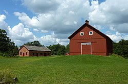
 The remaining buildings of North Oaks Farm are preserved by the city. | |
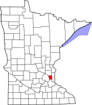
 Location of the city of North Oaks within Ramsey County, Minnesota | |
| Coordinates: 45°05′59″N 93°07′10″W / 45.09972°N 93.11944°W[1] | |
| Country | United States |
| State | Minnesota |
| County | Ramsey |
| Area | |
• Total | 8.62 sq mi (22.33 km2) |
| • Land | 6.91 sq mi (17.90 km2) |
| • Water | 1.71 sq mi (4.43 km2) |
| Elevation | 892 ft (272 m) |
| Population (2020) | |
• Total | 5,272 |
| • Density | 762.95/sq mi (294.58/km2) |
| Time zone | UTC-6 (Central (CST)) |
| • Summer (DST) | UTC-5 (CDT) |
| ZIP codes | 55126, 55127 |
| Area code | 651 |
| FIPS code | 27-47104[3] |
| GNIS feature ID | 2395259[1] |
| Website | City of North Oaks |
North Oaks is an exurban[4] city 10 miles (16 km) north of St. Paul in Ramsey County in the U.S. state of Minnesota. The population was 4,469 at the 2010 census.[5]
Formerly a gated community that now posts private access signage, all land is owned by homeowners with the North Oaks Home Owners Association maintaining all roads, plowing, parks, facilities, and recreation trails. Each homeowner's property extends halfway into the street. There is also a city government with a Mayor and City Council that administers basic services such as fire, police, planning, and licensing. The city owns no property.
History
[edit]Structured around Pleasant Lake, the area began as a water source for the Saint Paul municipal water system, which still maintains water access rights today. The land was later purchased by Saint Paul magnate James J. Hill in 1883 and expanded into a 5,000-acre (20 km2) breeding and hobby farm.
His son Louis Hill later owned North Oaks Farm until death in 1950. Ownership passed to Louis' children who decided to develop the land into a model residential community. They incorporated the North Oaks Company with a mission to build with respect for the natural environment, having witnessed metropolitan sprawl during this time. To ensure their mission would be fulfilled, land was subdivided and sold with a warranty deed that created the North Oaks Home Owners’ Association (NOHOA) to be responsible for roads and recreation. Each deed placed each home's property line halfway into the street, placing all roads into private ownership.
Remaining land in the city is owned by the North Oaks Company. The original farm buildings have been restored with informational displays. They are not open to the public however as North Oaks is private. Two of the remaining structures, the Blacksmith Shop and Machine Shop and Dairy Building, are listed on the National Register of Historic Places.
In May 2008, NOHOA sent a letter to internet search company Google, stating that its Street View software contained images that violated their trespassing ordinance, and requested their removal. Google complied, so there is no street view available for the roads within North Oaks.[6]
Geography
[edit]According to the United States Census Bureau, the city has a total area of 8.63 square miles (22.35 km2), of which 6.92 square miles (17.92 km2) is land and 1.71 square miles (4.43 km2) is water.[7]
Demographics
[edit]| Census | Pop. | Note | %± |
|---|---|---|---|
| 1960 | 803 | — | |
| 1970 | 2,002 | 149.3% | |
| 1980 | 2,846 | 42.2% | |
| 1990 | 3,386 | 19.0% | |
| 2000 | 3,883 | 14.7% | |
| 2010 | 4,469 | 15.1% | |
| 2020 | 5,272 | 18.0% | |
| U.S. Decennial Census[8] | |||
2010 census
[edit]As of the census[9] of 2010, there were 4,469 people, 1,746 households, and 1,378 families residing in the city. The population density was 645.8 inhabitants per square mile (249.3/km2). There were 1,868 housing units at an average density of 269.9 per square mile (104.2/km2). The racial makeup of the city was 93.0% White, 0.4% African American, 0.2% Native American, 5.2% Asian, 0.1% from other races, and 1.1% from two or more races. Hispanic or Latino of any race were 1.2% of the population.
There were 1,746 households, of which 27.5% had children under the age of 18 living with them, 74.3% were married couples living together, 3.1% had a female householder with no husband present, 1.5% had a male householder with no wife present, and 21.1% were non-families. 18.9% of all households were made up of individuals, and 14% had someone living alone who was 65 years of age or older. The average household size was 2.49 and the average family size was 2.84.
The median age in the city was 53.1 years. 20.9% of residents were under the age of 18; 4.1% were between the ages of 18 and 24; 11.7% were from 25 to 44; 37.7% were from 45 to 64; and 25.6% were 65 years of age or older. The gender makeup of the city was 48.2% male and 51.8% female.
2000 census
[edit]As of the census[3] of 2000, there were 3,883 people, 1,300 households, and 1,177 families residing in the city. The population density was 531.0 inhabitants per square mile (205.0/km2). There were 1,332 housing units at an average density of 182.1 per square mile (70.3/km2). The racial makeup of the city was 93.33% White, 0.31% African American, 0.15% Native American, 4.61% Asian, 0.03% Pacific Islander, 0.57% from other races, and 1.00% from two or more races. Hispanic or Latino of any race were 1.21% of the population.
There were 1,300 households, out of which 41.5% had children under the age of 18 living with them, 86.5% were married couples living together, 2.6% had a female householder with no husband present, and 9.4% were non-families. 7.6% of all households were made up of individuals, and 3.2% had someone living alone who was 65 years of age or older. The average household size was 2.92 and the average family size was 3.08.
In the city, the population was spread out, with 27.6% under the age of 18, 4.7% from 18 to 24, 17.6% from 25 to 44, 38.5% from 45 to 64, and 11.6% who were 65 years of age or older. The median age was 45 years. For every 100 females, there were 99.2 males. For every 100 females age 18 and over, there were 96.0 males.
The median income for a household in the city was $149,158, and the median income for a family was $152,380. Males had a median income of $100,000 versus $47,019 for females. The per capita income for the city was $72,686. None of the families and 1.9% of the population were living below the poverty line, including no under-eighteens and 9.6% of those over 64. North Oaks is listed among the highest-income places in the United States.
Sports
[edit]Golf
[edit]Notable people
[edit]- Joe Alt (Born 2003), NFL player
- Marc Asch (Born 1946), Minnesota state representative
- Sydney Brodt (Born 1998), ice hockey player with the PWHPA and the American National team
- Mike Hoeffel (Born 1989), ice hockey player with the Iserlohn Roosters
- Paul Moga (Born 1972), Brigadier General in the United States Air Force
- Walter Mondale (Born 1928) 42nd Vice President of the United States under Jimmy Carter
- John William Vessey Jr. {1922 – 2016) US Army general
References
[edit]- ^ a b c U.S. Geological Survey Geographic Names Information System: North Oaks, Minnesota
- ^ "2020 U.S. Gazetteer Files". United States Census Bureau. Retrieved July 24, 2022.
- ^ a b "U.S. Census website". United States Census Bureau. Retrieved January 31, 2008.
- ^ Met Council. "Community Designations" (PDF). Metropolitan Council. Archived (PDF) from the original on November 30, 2021.
- ^ "2010 Census Redistricting Data (Public Law 94-171) Summary File". American FactFinder. U.S. Census Bureau, 2010 Census. Retrieved April 23, 2011.[dead link]
- ^ Pabst, Lora (May 31, 2008). "North Oaks tells Google Maps: Keep out - we mean it". Minneapolis Star-Tribune. Retrieved April 1, 2009.
- ^ "US Gazetteer files 2010". United States Census Bureau. Archived from the original on February 20, 2011. Retrieved November 13, 2012.
- ^ "Census of Population and Housing". Census.gov. Retrieved June 4, 2015.
- ^ "U.S. Census website". United States Census Bureau. Retrieved November 13, 2012.

